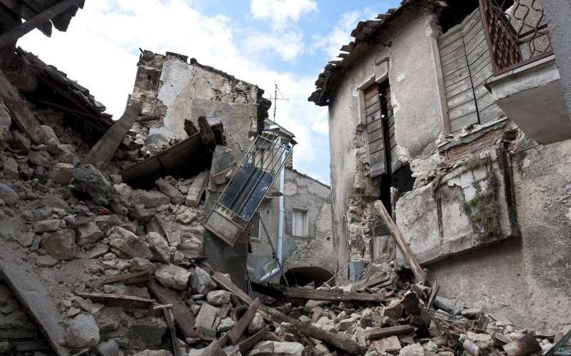
Researchers develop framework for modeling post-earthquake infrastructure resilience
Researchers at Oregon State University have developed a computational model for predicting the resilience of local and regional infrastructure networks and the recovery time for impacted communities following a massive earthquake and tsunami in the Cascadia Subduction Zone.
俄勒冈州立大学的研究人员开发了一个计算模型,用于预测卡斯卡迪亚俯冲带发生大地震和海啸后,当地和区域基础设施网络的恢复能力以及受影响社区的恢复时间。
The work is important, the researchers note, because some studies predict a 7% to 11% probability of a major quake—a “full-margin rupture”—occurring in the next 50 years along the offshore fault, which extends from British Columbia to northern California.
研究人员指出,这项工作很重要,因为一些研究预测,未来50年沿从不列颠哥伦比亚省延伸至加利福尼亚州北部的近海断层发生大地震的概率为7%至11%——即“完全边缘断裂”。
The new research, led by College of Engineering doctoral student Dylan Sanderson, involved transportation networks but the model is designed as a framework for use in other types of networks as well, such as water and electrical power networks. The study focused on 18 communities along the Oregon coast, from Astoria-Warrenton to Brookings.
这项由工程学院博士生迪伦·桑德森领导的新研究涉及交通网络,但该模型被设计为用于其他类型网络的框架,如水和电力网络。这项研究集中在俄勒冈州海岸沿线的18个社区,从阿斯托里亚沃伦顿到布鲁金斯。
“Our work looks at the connectivity of Oregon communities after ‘the really big one’ and how long it might take the transportation network to recover from the damages due to a magnitude 9 earthquake and tsunami,” said co-author Dan Cox, professor of civil and construction engineering at Oregon State. “We look at connectivity from two perspectives: a local index related to getting around within a community, and a regional index related to going from the community to other locations. We show that without regional considerations, recovery time may be severely underpredicted.”
“我们的工作着眼于“真正大地震”之后俄勒冈社区的连通性,以及交通网络从9级地震和海啸造成的破坏中恢复所需的时间,”合著者、俄勒冈州立大学土木和建筑工程教授丹·考克斯说。“我们从两个角度看待连通性:一个是与社区内出行相关的本地指数,另一个是关于从社区到其他地点的区域指数。我们表明,如果不考虑区域因素,恢复时间可能会严重低估。”
Findings of the study were published in the Journal of Infrastructure Systems.
研究结果发表在《基础设施系统》杂志上。
“Our work is still ongoing, so we haven’t taken our results to the communities yet, but we are planning to meet with them as a next step,” Cox said.
考克斯说:“我们的工作仍在进行中,因此我们还没有将结果传达给社区,但我们计划下一步与他们会面。”
The Cascadia Subduction Zone was the site of an estimated magnitude 9 earthquake in 1700 and is building up stress where the Juan de Fuca Plate is sliding underneath the North American Plate.
卡斯卡迪亚俯冲带是1700年发生9级地震的地点,在胡安·德富卡板块在北美板块下方滑动的地方,应力正在增加。
Earthquake magnitude is measured on a logarithmic 1 to 10 scale—each whole number represents a 10-fold increase in measured amplitude and a 31-fold increase in released energy.
地震震级以1到10的对数标度进行测量。每个整数表示测量振幅增加10倍,释放能量增加31倍。
The largest recorded earthquake was a 1960 temblor in Chile that measured 9.5. The 2011 quake that led to significant damage and radioactive release at the Fukushima nuclear power plant in Japan was measured at 9.0.
有记录以来最大的地震是1960年智利发生的9.5级地震。2011年日本福岛核电站发生了9.0级地震,造成重大破坏和放射性释放。
Sanderson, Cox, Andre Barbosa of the College of Engineering and John Bolte of the College of Agricultural Sciences analyzed the 18 Oregon communities individually and together as a regional network extending about 60 miles to the east, considering factors such as earthquake ground shaking, tsunami inundation depth and proximity both to airports and to highway and bridge maintenance facilities.
工程学院的桑德森、考克斯、安德烈·巴博萨和农业科学学院的约翰·博尔特分别分析了俄勒冈州18个社区,并将其合并为一个向东延伸约60英里的区域网络,考虑了地震地面震动、海啸淹没深度以及机场、公路和桥梁维护设施附近的因素。
Read more at Phys.org
在Phys.org阅读更多