The Controversial Plan to Unleash the Mississippi River
The creation story told by the Chitimacha people in Louisiana describes the world in its earliest days as a wide expanse of water. Then the Great Creator instructed crawfish to dive down and bring up a bit of mud. Geologists tell a similar tale, though their sculptor is the Mississippi River: For thousands of years, it dumped soils stolen off the continent into the Gulf of Mexico. Thus the river formed its delta, a vast and muddy and ever-changing landscape where the water once forked into many paths to the sea.
路易斯安那州奇蒂马查人讲述的创造故事将世界最早描述为一片广阔的水域。然后,伟大的造物主指示小龙虾潜水并带出一点泥土。地质学家讲述了一个类似的故事,尽管他们的雕塑家是密西西比河:数千年来,密西西比河将随河而来的土壤倒入墨西哥湾。因此,这条河形成了它的三角洲,这是一个广阔、泥泞、不断变化的景观,这里的水曾经分叉成许多通向大海的小径。
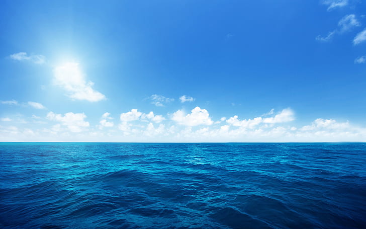
These days, though, the river is largely restricted to one channel. Imprisoned within artificial levees, it’s no longer able to deposit its mud according to hydrological whim; instead, the river spits its sediment into the abyss of the deep sea. The consequences are grim: The existing mudscape is sinking. The ocean is rising. Over the past nine decades, more than 5,000 square kilometers of delta land in Louisiana has disappeared.
然而,如今这条河基本上只限于一条河道。由于被囚禁在人工堤坝内,它不再能够根据水文奇想沉积淤泥;相反,河流将其沉积物吐入深海深渊。后果是严峻的:现有的泥石流正在下沉。海水正在上涨。在过去的90年里,路易斯安那州超过5000平方公里的三角洲土地消失了。
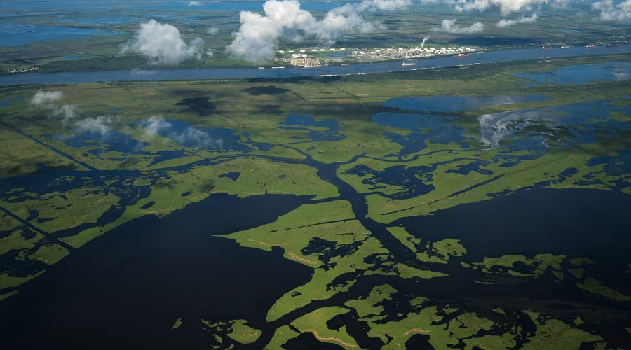
Few places are going faster than Plaquemines Parish, which encompasses the muddy land along the river’s final 100 or so kilometers, where New Orleans’ exurbs give way to a smattering of rural communities. (A parish is the local equivalent of a county, a remnant of Louisiana’s French colonial history.) One morning last summer, as we weave in his skiff through the parish’s marshland, Richie Blink tells me that the federal government has recently deleted 30-odd names from local nautical maps. Fleur Pond, Dry Cypress Bayou, Tom Loor Pass, Skipjack Bay: All have become undifferentiated, unlabeled expanses of open ocean.
很少有地方能比Plaquemines教区走得更快。Plaquemine教区涵盖了沿河最后100公里左右的泥泞地带,新奥尔良的郊区被一小撮农村社区所取代。(一个教区在当地相当于一个县,路易斯安那州法国殖民历史的遗迹。)去年夏天的一个早上,当我们乘坐他的小船穿过教区的沼泽地时,里奇·布林克告诉我,联邦政府最近从当地的航海图上删除了30多个名字。芙蓉池、干涸的柏树湾、汤姆·鲁尔山口、斯基普杰克湾:所有这些都已成为一片未分化、未标记的开阔海洋。
Now, the state government wants to open a gap in the levee to divert some of the river’s muddy water back into the marshes, allowing the river to resume its old task of construction. Work on the gap could begin in early 2023, assuming that the US Army Corps of Engineers, the federal agency that oversees waterway infrastructure, grants its official approval later this year. The Mid-Barataria Sediment Diversion—which is named for Barataria Bay, where the released river water will build a new “subdelta”—has been under discussion for years, but now, on the eve of destruction, it’s come under a firestorm of criticism from shrimpers worried about their livelihood; homeowners concerned about flooding; and environmentalists dismayed at the potential loss of bottlenose dolphins, a federally protected species. The diversion is intended to build new marshland, but it’s sometimes depicted as the latest assault on the region’s rural communities—which, according to critics, are about to be sacrificed again for the sake of nearby urban New Orleans.
现在,州政府希望在堤坝上开辟一个缺口,将河流的部分浑水引回沼泽,让河流恢复原来的建设任务。如果负责监督航道基础设施的联邦机构美国陆军工程兵团今年晚些时候正式批准,土地缺口的工作可能会在2023年初开始。巴拉塔里亚中部的泥沙分流以巴拉塔里亚湾命名,在那里释放的河水将形成一个新的“亚三角洲”——已经讨论了多年,但现在,在破坏前夕,它遭到了担心生计的捕虾人的猛烈批评;房主担心洪水;环境保护主义者对瓶鼻海豚这一联邦保护物种的潜在损失感到失望。改道的目的是建设新的沼泽地,但有时会被描述为对该地区农村社区的最新攻击,批评人士称,为了附近的城市新奥尔良,这些农村社区将再次被牺牲。
Blink, an ecotour guide, serves on the Plaquemines Parish council and is the sole member who has not voted to oppose the project. “We are facing these massive changes,” he tells me as the solid ground disappears behind us and we speed into open water. Either the diversion will alter the ecosystem, or the loss of land will. One way or another, the parish will have to do something new if it wants to survive. “We have to imagine this delta of the future,” he says.
生态旅游指南的布林克是Plaquemines教区委员会的成员,也是唯一没有投票反对该项目的成员。“我们正面临着这些巨大的变化,”他告诉我,当坚实的地面消失在我们身后,我们快速驶入开阔的水域。要么改道会改变生态系统,要么土地流失会造成破坏。不管怎样,如果教区想要生存,它将不得不做一些新的事情。“我们必须想象未来的三角洲,”他说。
It strikes me, though, that we’ve often failed to imagine the delta of the present. Despite all the focus on land loss and land building, we rarely pause to discuss what we mean by land. And here in Louisiana, land—and who should control it—is a sometimes squishy idea.
然而,令我震惊的是,我们常常无法想象现在的三角洲。尽管我们关注的是土地损失和土地建设,但我们很少停下来讨论土地的含义。在路易斯安那州,土地和谁应该控制它有时是个模糊的想法。
THE MISSISSIPPI RIVER is truly massive, combining three major tributaries that together drain 32 US states and two Canadian provinces, from Alberta to New York to New Mexico. Together, these various tributaries once sent as much as 290 million metric tons of dirt to the Gulf of Mexico each year, stacking it into an ever-growing lobe of land. Eventually, the lobe would grow so long that one of the side channels forking away from the river would become a tempting shortcut for the Mississippi. Lured away, the river jumped—or avulsed, in the parlance of geology—on a roughly millennial schedule, sending its torrent of water down one of these channels, building in a new direction.
密西西比河是一条巨大的河流,由三条主要支流汇合而成,共流经美国32个州和加拿大两个省,从艾伯塔到纽约再到新墨西哥。这些支流加在一起,每年向墨西哥湾输送多达2.9亿吨的泥土,将其堆积成不断增长的陆地。最终,该河的分支会长得很长,从河中分岔出来的一条旁道将成为通往密西西比河的一条诱人的捷径。用地质学的说法,这条河被引诱离开后,会跳跃或崩塌,大约在千年的时间里,沿着其中一条河道倾泻而下,朝着一个新的方向发展。
This process has yielded a branching network of overlapping sub-deltas that reach like splayed fingers into the Gulf of Mexico. Each sub-delta holds at its center a line of water, an active or abandoned channel of the Mississippi River. The highest ground, rarely more than a few meters above sea level, sits next to these channels; this is where the most mud has been deposited. These “ridges” can stretch for more than 150 kilometers, though they’re just a few kilometers wide. The modern Plaquemines Parish sub-delta began forming perhaps 750 years ago, and was still under construction when French explorers arrived in the late 17th century. The place seemed to consist “of nothing more than two narrow strips of land, about a musket shot in width,” one member of the crew wrote. Over the next century, French settlers marked the growth of the parish by noting how far the riverbank extended past a fort they’d built at the river’s mouth.
这一过程产生了一个由重叠的亚三角洲组成的分支网络,像张开的手指一样延伸到墨西哥湾。每个亚三角洲的中心都有一条水线,一条活跃或废弃的密西西比河河道。最高的地面,很少高于海平面几米,位于这些水道旁边;这是泥浆沉积最多的地方。这些“山脊”可以延伸超过150公里,尽管它们只有几公里宽。现代Plaquemines教区次三角洲大约在750年前开始形成,17世纪末法国探险家抵达时仍在建设中。一名工作人员写道,这个地方似乎“只有两条狭长的土地,宽度大约为一发步枪。”。在接下来的一个世纪里,法国定居者注意到河岸延伸了多远,超过了他们在河口修建的一座堡垒,从而标志着该教区的发展。
A second type of landform stretches like webbing between the fingers: the marshland that makes up most of the coastal landscape. Here, the mud never stacked high enough to break the ocean surface, but it came close enough to allow marsh grass to root. It’s a world of rich organic soils, though rather unsteady: In places, mats of plants float atop the water, unattached to the soils below, so that if you step onto the grass, it will wobble and sink. The delta begins roughly 500 kilometers upstream of the river’s mouth, and as of 1930, covered nearly 20,000 square kilometers—an area almost the size of New Jersey.
第二种地貌像手指间的蹼一样伸展:构成大部分沿海景观的沼泽地。在这里,淤泥堆积的高度从来都不足以冲破海洋表面,但它接近到足以让沼泽草生根。这是一个有机土壤丰富的世界,尽管相当不稳定:在某些地方,植物垫漂浮在水面上,与下面的土壤无关,因此如果你踩到草地上,它会摇晃并下沉。三角洲始于河口上游约500公里处,截至1930年,其面积接近20000平方公里,几乎相当于新泽西州的面积。
The water running through the marshes is fresh inland and grows saltier closer to the sea. Many species—blue crabs, white shrimp—move across this gradient throughout their life cycles, and the marsh, as a result, offers an abundance of life. The ever-shifting landscape makes research difficult, but evidence suggests that people arrived on the ridges even as they were forming, perhaps to establish short-term hunting and fishing camps amid the new marsh.
流经沼泽的水在内陆是新鲜的,在靠近大海的地方变得更咸。许多种类的蓝蟹、白虾在它们的整个生命周期中都在这个梯度上移动,因此,沼泽提供了丰富的生命。不断变化的地形使研究变得困难,但有证据表明,人们在形成山脊的时候就来到了山脊上,也许是为了在新沼泽中建立短期狩猎和捕鱼营地。
The colonial records are somewhat sparse when it comes to Indigenous life within the delta. The first French explorers noted various groups, including the Quinipissa, the Yakni-Chito, the Washa, the Chawasha, and the Chitimacha. Archaeological evidence suggests that at the time of contact, people lived in small villages mostly focused on gathering fish and other wetland resources. The delta was an important crossroads, linking coastal travelers with upriver communities; French explorers noted that so many canoes had been dragged across one ridge-top portage that they had produced a “rather good road.” The Choctaw, one of the larger tribes on the land that would become the US South, called this spot, or perhaps the whole delta, Bulbancha—the place of other languages.
当涉及三角洲内的土著生活时,殖民地的记录有些稀少。第一批法国探险家注意到了各种群体,包括基尼皮萨人、雅克尼人、瓦沙人、查瓦沙人和奇蒂马查人。考古学证据表明,在接触时,人们生活在小村庄,主要集中于采集鱼类和其他湿地资源。三角洲是连接沿海旅行者和上游社区的重要十字路口;法国探险家注意到,这么多独木舟被拖过了一个山脊顶部的港口,他们创造了一条“相当好的道路”。乔克托部落是美国南部陆地上较大的部落之一,他们称这个地方,或者说整个三角洲,布尔班查是其他语言的发源地。
The arrival of European settlers brought disease and slave raids and warfare, and by the time the French began keeping solid records in the 18th century, some Indigenous nations had disappeared, the survivors integrating with neighboring tribes. Some groups slipped into corners of the delta rarely traversed by colonists. People from various villages and traditions settled together, and today the US government refuses to officially recognize some of these groups as tribes, since there is no written record of their beginnings.
欧洲定居者的到来带来了疾病、奴隶袭击和战争,当法国人在18世纪开始保持可靠记录时,一些土著民族已经消失,幸存者与邻近部落融合。一些群体溜进了殖民者很少穿越的三角洲的角落。来自不同村庄和传统的人们定居在一起,今天美国政府拒绝正式承认其中一些群体为部落,因为没有关于其起源的书面记录。
Read more at Wired.com
在Wired.com阅读更多